Why was the Hetch Hetchy Valley selected over the alternatives that were considered by San Francisco, by the Army Corp of Engineers, by the Interior Department, and by Congress? There were a variety of factors that were important in selecting the dam and reservoir site including:
- • size and regularity of the water source
- • need for filtration of the water
- • elevation of the source at the dam site
- • possibility of power generation
- • distance from San Francisco
- • extent of the watershed draining into the source
- • geology of the dam site as it affected construction costs
- • geology of the lake bed as it related to water loss due to seepage
|

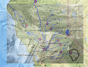
Click map to enlarge
|
San Francisco engineers and city leaders obviously wanted the combination of factors leading to the lowest construction and operation costs and a source of water that would be adequate for participating Bay Area communities into the 21st century. In the spirit of Progressive era politics they wanted the greatest value for the largest number of Californians served by the resource. In their minds these considerations far outweighed the scenic value of the valley to the few who were able to visit Hetch Hetchy. The fact that the valley was part of a national park carried little weight.
How did the alternatives measure up? The activities below allow you to examine the data available to Congress in 1913 for yourself.
Open the map to explore the relevant information. Layers showing the potential water sources themselves and the proposed intake points are displayed. Select to Show the Table associated with the Water Options - 1912 layer. Make use of the Table Options >> Filter choice to address the questions below.
To Start You Thinking -
1) Measure to determine which of the sites are within 50 miles of San Francisco? 100 miles? 150 miles? 250 miles? Record your results on the Examining the Alternatives worksheet.
2) As indicated above there were a number of important criteria applied in the selection process. Let's start with the most fundamental: the extent of the water supply. San Francisco engineers estimated that there needed to be a minimum flow of 400 million gallons of water per day (MGD) to assure an adequate supply for the Bay Area communities involved into the 21st century. Determine which of the potential sites met this criteria.
3) Apply the other criteria to the possible water sources and you will see the list gradually diminish. Start with the need for filtration and eliminate those sources that would require the water to be filtered.
The list of choices is obviously significantly reduced. Photos from potential dam sites along each of these rivers are included in the popup of each potential site in the San Francisco Water Options Scene. If you have 3-D access click the slides at the bottom of that version of the map to zoom in on each site.
| To... |
Click... |
• View & navigate 3-D scenes
|
View scenes
|

|
It's now your choice. Complete the Examining the Alternatives worksheet and summarize your conclusions about a new water source for San Francisco.
| 